
Understanding Alaska’s Tidal Dynamics
Alaska’s coastline, spanning over 6,600 miles, experiences some of the most dramatic tidal ranges in the world. The state’s tidal patterns are characterized by extreme vertical water level fluctuations, with certain regions experiencing tidal ranges exceeding 30 feet. This phenomenon is driven by a combination of astronomical influences, geographic features, and oceanographic conditions unique to the North Pacific region.
The tidal forces generated by the moon and sun create predictable patterns along Alaska’s coast. However, Alaska’s complex bathymetry—the underwater topography of the ocean floor—amplifies these astronomical tides into exceptional vertical displacements. The funnel-shaped inlets and bays throughout the state, particularly in Southeast Alaska and Cook Inlet, concentrate tidal energy, creating some of the highest tides found anywhere on Earth.
The Science Behind Alaska’s Extreme Tides
Tidal movements are fundamentally governed by gravitational interactions between the Earth, moon, and sun. When these celestial bodies align, their combined gravitational pull creates spring tides—the highest high tides and lowest low tides of the lunar month. Conversely, neap tides occur when gravitational forces partially counteract one another, resulting in more moderate tidal ranges.
Alaska’s geographic characteristics significantly amplify these astronomical forces. The state’s numerous fjords, estuaries, and enclosed bays create natural resonance chambers that can magnify tidal waves. When incoming tidal energy enters these constricted waterways, the water has nowhere to disperse horizontally, forcing it to move vertically instead. This concentration of tidal energy produces the extreme ranges for which Alaska is renowned.
Key Tidal Regions in Alaska
- Cook Inlet: Located south-central Alaska, Cook Inlet experiences some of the world’s highest tides, with ranges reaching 38 feet or more during spring tides
- Southeast Alaska: The Inside Passage and surrounding waters experience significant tidal ranges, typically between 20 and 26 feet
- Bristol Bay: This region experiences substantial tidal ranges that influence salmon migration patterns and commercial fishing operations
- Glacier Bay: Known for dramatic tidal fluctuations that affect glacial dynamics and marine ecosystems
Impacts on Coastal Communities and Infrastructure
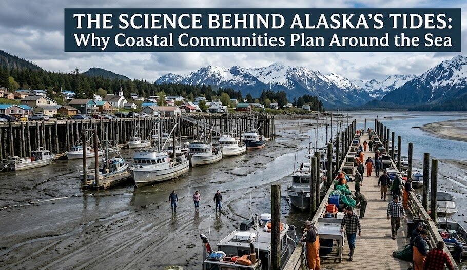
Alaska’s extreme tides present both challenges and opportunities for coastal planning and development. Municipalities and private developers must account for significant vertical water level variations when designing ports, docks, and other waterfront infrastructure. Failure to properly accommodate tidal ranges can result in costly structural damage, operational inefficiencies, and safety hazards.
Transportation infrastructure along Alaska’s coast must be engineered to withstand the constant expansion and contraction caused by tidal cycles. Floating docks and adjustable mooring systems have become standard features in Alaska’s harbors, allowing vessels and facilities to rise and fall with the tides while maintaining operational integrity.
Commercial Fishing and Tidal Considerations
Commercial fishing operations depend heavily on understanding local tidal patterns. Fish migration routes, abundance in specific areas, and optimal harvest times are all influenced by tidal cycles. Fishermen in Alaska have developed sophisticated knowledge of how tides affect fish behavior, allowing them to time their operations for maximum efficiency and catch rates.
Environmental and Ecological Implications
Alaska’s tidal ecosystem supports diverse marine life adapted to extreme environmental conditions. Intertidal zones—the areas between the highest high tide and lowest low tide—are subject to dramatic daily changes in water coverage, temperature, and salinity. Organisms inhabiting these regions have evolved remarkable physiological and behavioral adaptations to survive these harsh conditions.
Tidal ranges directly influence habitat availability for salmon, shellfish, sea otters, and numerous bird species. The broad mudflats and exposed rocky shores revealed during low tides provide critical feeding grounds for migratory birds traveling between Arctic breeding grounds and southern wintering areas. Similarly, the submerged habitat available during high tides offers nursery grounds and feeding areas for juvenile fish and marine mammals.
Climate Change and Shifting Tidal Patterns
Rising sea levels, driven by climate change and glacier melt, are altering Alaska’s tidal dynamics. As baseline ocean levels increase, the relative tidal range—the difference between high and low tide—may shift in complex ways depending on local factors. Additionally, ongoing isostatic adjustments from glacial retreat are causing some regions to experience land subsidence while others experience land uplift, further complicating tidal patterns and coastal planning considerations.
Tidal Energy Potential
Alaska’s extreme tidal ranges represent a significant untapped renewable energy resource. Tidal stream turbines and tidal barrages could potentially generate substantial quantities of clean electricity, particularly in regions with high tidal ranges and strong tidal currents. Several pilot projects and feasibility studies have been conducted in Alaska, examining the viability of harnessing tidal energy while minimizing environmental impacts on marine ecosystems.
Best Practices for Coastal Planning in Tidal Environments
Successful coastal development in Alaska requires comprehensive understanding of local tidal characteristics. Engineering standards must account for maximum predicted tidal ranges, storm surge potential, and historical extreme water level events. Planners should incorporate flexible design approaches that accommodate variable water levels and allow for future adjustments as sea levels continue to change.